
Tensar+ ontwerpsoftware
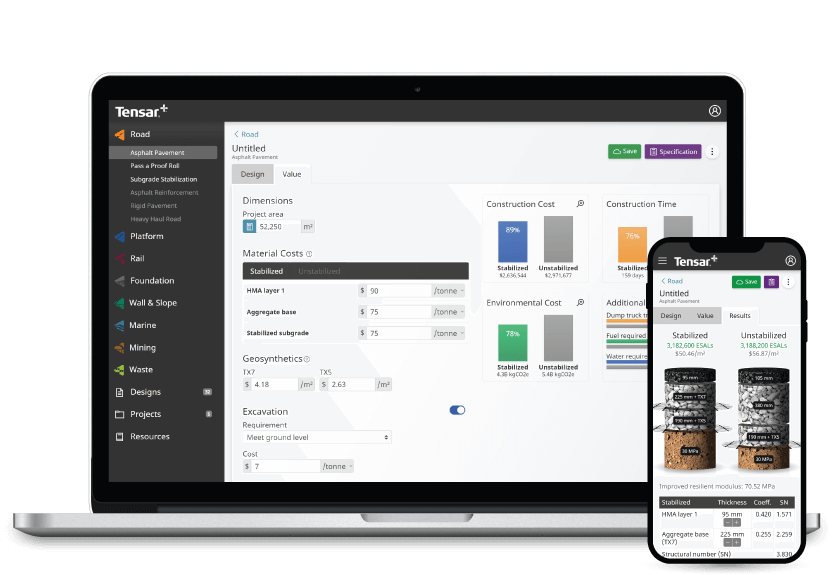
Tensar+ biedt kostenloos te gebruiken wegenbouwkundige en geotechnische ontwerpsoftware die overal en altijd online toegankelijk is. Gebruik het platform om uw project te ontwerpen, de specificaties/omschrijving aan te passen en de kostenbesparingen in real-time te zien.
Ontwerp projecten voor uiteenlopende toepassingen zoals: wegen, opstelplaatsen, spoorwegen, funderingen, muren, taluds, erosie en hydraulisch. U vindt een reeks ontwerpmodules voor elke toepassing waarbij regelmatig nieuwe modules beschikbaar komen.
Met het Tensar+ platform ontwerpen kunt u:
- Projectspecificaties of omschrijvingen ontwerpen en evalueren
- Alternatieve materialen en projectomstandigheden vergelijken
- De kosten- en tijdbesparingen in real-time bekijken terwijl u parameters wijzigt
- De milieuimpact van uw projecten beschouwen
Nieuw Module: CROW (C1001)
Speciaal voor onze Nederlandse gebruikers, hebben we zojuist een nieuwe module toegevoegd: CROW (C1001) Betonstraatsteen verhardingen. Met:
✔️ Betonstraatsteen verhard of onverhard ontwerp
✔️ Een variatie aan optionele onderfunderingen
✔️ Direct vergelijk tussen geogrid gestabiliseerd en niet-gestabiliseerd
✔️ Automatische kostenraming
✔️ Automatische MKI waarde raming
✔️ RAW bestektekst
✔️ Gedetailleerde berekeningsuitdraai
✔️ Ontwerpberekening 100% conform CROW C1001 publicatie
Kies uit verschillende bouw- en geotechnische ontwerpsoftwaremodules
Tensar+ heeft meerdere modules beschikbaar ter ondersteuning van uw bouw- en geotechnische ontwerpprojecten. Ontdek onze huidige en aanstaande ontwerpmodules hieronder.
Software voor wegenbouw
Met onze softwaremodule voor wegontwerp en wegenbouw kunnen ontwerpers de parameters en voorwaarden van projecten - voorafgaand aan de aanleg - visualiseren, voorbereiden en begrijpen, inclusief de specificaties voor gestabiliseerde lagen. Dankzij de mechanische stabilisatie van de ongebonden lagen van een wegverharding kan op de kosten en de koolstofemissies maximaal worden bespaard door de dikte van het wegdek bij de aanleg te verminderen. De benadering van Tensar maakt gebruik van de meest recente kennis over de werking van geogrids in een verharding die onderhevig is aan dynamische verkeersbelasting.
Software voor tijdelijke opstelplaatsen
Tijdelijke opstelplaatsen zijn een ongelooflijk belangrijk aspect van vele bouwprojecten, omdat ze bouwvakkers en ingenieurs een stabiele en veilige oppervlak bieden. Met de ontwerpmodule voor tijdelijke opstelplaatsen in Tensar+ kunt u gebruik maken van Tensars meest recente toepassingstechnologie voor mechanisch gestabiliseerde opstelplaatsen. Bovendien zorgt u zo voor veilige opstelplaatsen die projectkosten besparen en milieuvriendelijker zijn. De ontwerpbenadering van Tensars “T-Value” is een betrouwbaar alternatief voor de in BR470 geboden richtlijnen, met een bewezen staat van dienst. Deze benadering is geïmplementeerd in Tensar+-software.
Software voor funderingstabilisatie
Werken op zachte of variabele grond brengt gewoonlijk aanzienlijke bouwproblemen met zich mee, zodat het ontwerpen van een veilige, mechanisch gestabiliseerde laag voorafgaand aan de bouw van essentieel belang is. Met de funderingstabilisatie-module van Tensar+ kunnen - voorafgaand aan de bouw - mechanisch gestabiliseerde lagen worden ontworpen. Hierdoor wordt de ondergrond verder beschermd en wordt de draagkracht verbeterd. Tensars ontwerpmethodes en oplossingen voor funderingstabilisatieworden universeel geaccepteerd en toegepast.
Meer modules binnenkort
We hebben verdere ontwerpmodules die nog moeten worden vrijgegeven. De velden hiervoor hebben op het platform nog een grijze achtergrond. Enkele van onze toekomstige modules omvatten:
- Zwaar belaste, onverharde wegen
- CD225: Ontwerp voor nieuwe bestratingsfunderingen
- Ontwerp van de gehele verharding
- Ontwerp van muren en hellingen
Om op de hoogte te blijven van hun vrijgavestatus, kunt u zich vandaag nog gratis aanmelden bij Tensar+. Klik op een module en selecteer de notificatieknop om een e-mail te ontvangen die u op de hoogte houdt van elke vrijgave van een module.
Wat is geotechnische ontwerpsoftware?
Geotechnische ontwerpsoftware is een gespecialiseerd programma waarmee ontwerpers geotechnische elementen van een terrein virtueel kunnen opbouwen. Met deze software kunnen ingenieurs op eenvoudige wijze oplossingen realiseren binnen het ontwerpen van onverharde wegen, opstelplaatsen, funderingstabilisatie en meer.
Tensar+ is een geotechnische software die specifiek bedoeld is om te werken met Tensar-geogrids, een baanbrekende oplossing voor wegen, spoorwegen en andere bereden oppervlakken. Omdat wij de marktleider voor geogrids voor stabilisatie- en wapening zijn, kunt u met onze bouwsoftware en onze producten prestatiegerichte oplossingen met gekwantificeerde Tensar-waarde genereren.
Geotechnische ontwerpsoftware voor desktop, mobiel en tablet
Onze geotechnische software is geheel cloudgebaseerd en gratis onderweg te gebruiken - toegang tot Tensar+ overal en altijd. Waar u ook bent. Extra hardeschijfruimte op uw apparaat is niet nodig, speciale vereisten om met uw ontwerpen te beginnen evenmin.
Report, research, and collaborate
With Tensar+ geotechnical design software, your project will be fully supported by our expert knowledge and years of extensive research. The resources section of our construction software contains many professional assets including product information, background on applications, and design methods and training. If you ever encounter any issues with using Tensar+, we have a large number of frequently asked questions to help you complete your project - and we also offer bespoke design support.
Reporting and collaborating on geotechnical projects has never been easier with our construction software. Not only can notes be added to the design for quick reference points when designing, reports can be exported and shared online, via email, or in print format.
How to get started with Tensar+ geotechnical design software
Getting started with Tensar+ is quick, easy, and free. Simply visit the Tensar+ website and sign up for an account, then start a new design or project directly from the homepage.